Snowshoeing route: Pont de Lachal - L’Echet
Saint-Colomban-des-Villards


Presentation
Route No. 50
Departure: Saint-Colomban-des-Villards / La Chal / Capaillan Bridge Parking
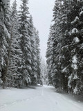
A superb discovery of "Medium" difficulty, through the forest, where you will likely spot chamois and ibex.
From the via ferrata parking lot, cross the Capaillan bridge and take the trail that descends to the right towards the stream. Cross the stream then take the trail that climbs to the left. Cross the clearing, then after the small wooded area, turn right and follow the trail that climbs slightly to a hairpin bend on the left. Continue on the trail that descends again. Once you reach the clearing, turn right onto the trail that descends through a wood before emerging into a wide clearing. Walk along the trees to the right of the clearing. At the bottom of this clearing, turn right, then take the trail that descends straight ahead, leaving an uphill trail on your right. Walk along the Glandon River, then cross the stream again before reaching the starting parking lot.
Période(s) d'ouvertureFrom 02/12 to 14/05 daily.
Subject to snow conditions.
Subject to snow conditions.
Contact
Snowshoeing route: Pont de Lachal - L’Echet
73130
Saint-Colomban-des-Villards
In Short
- Section :
- Sport
- Route :
- Distance (km) 3
- Daily duration (minutes) 100
- Elevation (m) 171
- VillageDeDepart :
- Saint-Colomban-des-Villards
Informations
- Natures terrain :
- Non-groomed itinerary
Equipments, Services
- Services :
- Pets welcome
Good to know
- Sitra promotion typology :
- Open air
Destination
Itinéraire raquette : Boucle de Bellecombe
73130
Saint-Colomban-des-Villards
GPS coordinates
Latitude : 45.280445
Longitude : 6.211193