Lac de l'Ane (2417m)
Saint-Colomban-des-Villards_Saint-Colomban-des-Villards - © Aude-AltitudeRando")
_Saint-Colomban-des-Villards - © Aude-AltitudeRando")
_Saint-Colomban-des-Villards - © Aude-AltitudeRando")
Presentation
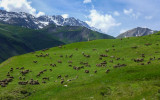
Start: At the limit of the Savoy and Isère. Be careful presence of herds.
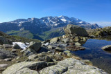
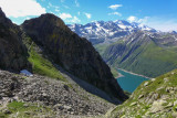
Starting from Rieu Claret on the border between Savoie and Isère, this hike leads to one of the wildest alpine lakes in the area. The trail climbs steadily above the Grand’Maison reservoir, offering superb views over the Eau d’Olle Valley, the Grandes Rousses massif, Pic de l’Étendard and the Aiguilles de l’Argentière. After a sustained ascent through grassy slopes and rocky terrain, the route reaches a high-altitude cirque where Lac de l’Âne lies hidden among the mountains. Surrounded by mineral landscapes and alpine pastures, the lake offers a peaceful and remote atmosphere. Depending on the season, hikers may spot ibex, and ptarmigans, while sheep flocks are commonly present during summer. Walking around the lake reveals a variety of viewpoints before returning to the starting point along the same route.
Safety information :
This route is recommended for hikers with good mountain experience. The ascent is demanding and parts of the route leave the main trail, following cairns through areas with limited waymarking. Good navigation skills are therefore required. One short section may also feel exposed for those uncomfortable with heights. Always check weather and ground conditions before setting out, particularly early in the season when lingering snow patches may still be present.
Période(s) d'ouvertureFrom 15/05 to 01/12 daily.
Contact
Lac de l'Ane (2417m)
Chef Lieu
73130
Saint-Colomban-des-Villards
In Short
- Section :
- Sport
- Levels of sporting experience :
- Level black - very hard
- Route :
- Distance (km) 7.11
- Daily duration (minutes) 330
- Elevation (m) 750
- VillageDeDepart :
- Saint-Colomban-des-Villards
Informations
- Natures terrain :
- Ground
- Pedestrian sports :
- Pedestrian sports
- Hiking itinerary
Equipments, Services
- Services :
- Pets welcome
Good to know
- Indication prix :
- Gratuit
- Sitra promotion typology :
- Open air
Prices
| Fares | Min | Max |
|---|---|---|
| Free | ||
Destination
Lac de l'Ane (2417m)
Chef Lieu
73130
Saint-Colomban-des-Villards
GPS coordinates
Latitude : 45.22458
Longitude : 6.139603