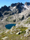
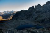
Lac et Col de la Croix
Saint-Colomban-des-Villards


Presentation
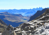
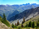
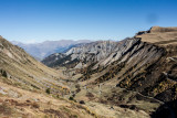
Route allowing to admire the Aiguilles of l’Argentière, the Madame hamlet, the Etendard and a part of the Chartreuse.
Start: Glandon pass. From the parking, go to the right and follow the ridge path (view on the road coming from St Colomban). At the Sous le Col d’en Haut hamlet, follow the path, cross the torrent. The path goes up progressively and joins up with another start on the Glandon pass.
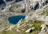
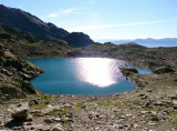
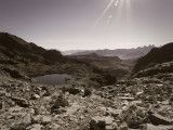
Descriptive: When you’re in the valley, stay on the right bank (do not cross the footbridge). After the lake at the Croix pass, a big rock remembers the past barrier separating Savoy from France: on one hand the Savoy cross, on the other side a fleur-de-lis.
Descriptive: When you’re in the valley, stay on the right bank (do not cross the footbridge). After the lake at the Croix pass, a big rock remembers the past barrier separating Savoy from France: on one hand the Savoy cross, on the other side a fleur-de-lis.
Période(s) d'ouvertureFrom 15/05 to 01/12 daily.
Contact
Lac et Col de la Croix
Saint Colomban des Villards / Col du Glandon
73130
Saint-Colomban-des-Villards
In Short
- Section :
- Sport
- Levels of sporting experience :
- Level red – hard
- Route :
- Distance (km) 8.8
- Daily duration (minutes) 300
- Elevation (m) 600
- VillageDeDepart :
- Saint-Colomban-des-Villards
Informations
- Pedestrian sports :
- Pedestrian sports
- Hiking itinerary
Equipments, Services
- Services :
- Pets welcome
Good to know
- Indication prix :
- Gratuit
- Sitra promotion typology :
- Open air
Tarifs
| Fares | Min | Max |
|---|---|---|
| Free | ||
Destination
Lac et Col de la Croix
Saint Colomban des Villards / Col du Glandon
73130
Saint-Colomban-des-Villards
GPS coordinates
Latitude : 45.239598
Longitude : 6.175504