Col de la Combe Madame (2641m)
Saint-Colomban-des-Villards_Saint-Colomban-des-Villards - © David Colson")
_Saint-Colomban-des-Villards - © David Colson")
Presentation
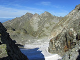
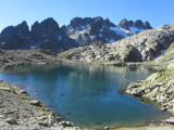
This demanding alpine circuit explores the wild Aiguilles de l’Argentière range in the heart of Belledonne. Lakes, remote valleys, glacial landscapes and outstanding mountain views combine to create a memorable adventure for experienced hikers.
Starting from the Col du Glandon, this high-mountain circuit loops around the impressive Aiguilles de l’Argentière, one of the most rugged and secluded areas of the Belledonne range. The route first climbs to the Col de la Croix, passing near the beautiful Lac de la Croix, whose deep blue waters contrast with the surrounding rocky peaks. The trail then descends into the remote Combe Madame, a striking mineral landscape overlooked by sharp summits rising to nearly 3,000 metres. Higher up, the route reaches the area of the Combe Madame Glacier before ascending to the Col de Combe Madame, the highest point of the circuit. The return journey is more demanding, crossing scree slopes, boulder fields and sections with little or no marked trail. Excellent fitness, mountain experience and strong navigation skills are essential. Depending on snow conditions, some sections may require appropriate alpine equipment. This is a rewarding and committing route through one of Belledonne’s finest high-mountain environments.
Période(s) d'ouvertureFrom 15/05 to 01/12 daily.
Contact
Col de la Combe Madame (2641m)
Chef Lieu
73130
Saint-Colomban-des-Villards
In Short
- Section :
- Sport
- Levels of sporting experience :
- Level black - very hard
- Route :
- Distance (km) 13
- Daily duration (minutes) 480
- Elevation (m) 1130
- VillageDeDepart :
- Saint-Colomban-des-Villards
Informations
- Natures terrain :
- Ground
- Pedestrian sports :
- Pedestrian sports
- Hiking itinerary
Equipments, Services
- Services :
- Pets welcome
Good to know
- Indication prix :
- Gratuit
- Sitra promotion typology :
- Open air
Prices
| Fares | Min | Max |
|---|---|---|
| Free | ||
Destination
Tour des Aiguilles de l’Argentière par les cols de la Croix et de Combe Madame
Chef Lieu
73130
Saint-Colomban-des-Villards
GPS coordinates
Latitude : 45.239001
Longitude : 6.176622