Snowshoe route: Bon Mollard
Saint-Colomban-des-Villards

Presentation
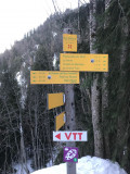
Route No. 46
Departure: Saint-Colomban-des-Villards / La Pierre / Virage résidence Goélia
A leisurely walk, with no significant elevation changes between meadows and forest.
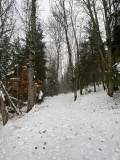
From the Goélia residence "Les chalets de Belledonne," take the path on the left above the large bend. This leads to the platform of an agricultural shed. The path turns right and continues along a wide, tree-lined track. The trail crosses a meadow, then enters the spruce forest. Arriving at Bon Mollard, turn left onto the descending path, then immediately left onto the slightly ascending track. The trail crosses a wood, emerges into a small meadow, and then rejoins the starting path. The return is flat to the Goélia residence, passing through the agricultural platform.
A leisurely walk, with no significant elevation changes between meadows and forest.
From the Goélia residence "Les chalets de Belledonne," take the path on the left above the large bend. This leads to the platform of an agricultural shed. The path turns right and continues along a wide, tree-lined track. The trail crosses a meadow, then enters the spruce forest. Arriving at Bon Mollard, turn left onto the descending path, then immediately left onto the slightly ascending track. The trail crosses a wood, emerges into a small meadow, and then rejoins the starting path. The return is flat to the Goélia residence, passing through the agricultural platform.
Période(s) d'ouvertureFrom 02/12 to 14/05 daily.
Contact
Snowshoe route: Bon Mollard
73130
Saint-Colomban-des-Villards
In Short
- Section :
- Sport
- Route :
- Distance (km) 3.7
- Daily duration (minutes) 90
- Elevation (m) 60
- VillageDeDepart :
- Saint-Colomban-des-Villards
Informations
- Natures terrain :
- Non-groomed itinerary
Equipments, Services
- Parking :
- Parking
- Services :
- Pets welcome
Good to know
- Sitra promotion typology :
- Open air
Destination
Itinéraire raquette : Bon Mollard
73130
Saint-Colomban-des-Villards
GPS coordinates
Latitude : 45.29319
Longitude : 6.236087