Black course
Saint-Colomban-des-Villards


Presentation
• Black route n°66
From the recreation area, head towards the hamlet of Nantchenu, then take an uphill, winding forest track to the Grange du Truc. You will then continue along a steep, grassy path towards the Côte Brune ridge.
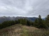
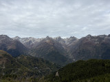
After a fairly strenuous climb, you will reach the Grand Truc viewpoint, offering a magnificent view of the Aiguilles d'Arves.
To begin the descent, retrace your steps to the start of the forest road, then take a very technical forest trail, with hairpin bends and roots, which will lead you to Le Plan. This trail passes under the Rogemont chairlift before returning to the recreation center via Nantchenu, as on the outward journey.
This route requires excellent riding skills and excellent physical fitness.
Km: 17.26 km
D+: 1119m
D-: 1123m
Level: black, very difficult
Time: 4h
Marking: FFC Marker + No. 66
Min Altitude: 1072m
Max Altitude: 2178m
Période(s) d'ouvertureAll year round daily.
Contact
Black course
le Chef-Lieu
73130
Saint-Colomban-des-Villards
- Spoken language(s) :

In Short
- Section :
- Sport
- Levels of sporting experience :
- Level black - very hard
- Route :
- Distance (km) 17.26
- Elevation (m) 1119
- VillageDeDepart :
- Saint-Colomban-des-Villards
Informations
- Natures terrain :
- Ground
Destination
Parcours noir
le Chef-Lieu
73130
Saint-Colomban-des-Villards
GPS coordinates
Latitude : 45.290972
Longitude : 6.223286