Le Coin
Saint-Colomban-des-Villards


Presentation
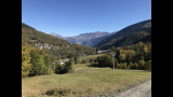
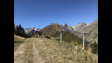
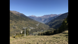
Starts: At some meters above the campside, take the path on the left when it comes from La Perrière. After some meters, go to the path going up. From the Nanchenu hamlet (at the foot of the slopes). Go to the torrent, cross it and go on the path (suitable for motor vehicles) the steepest (rise) which reach the ski alpine slope.
Période(s) d'ouvertureFrom 15/05 to 01/12 daily.
Contact
Le Coin
Chef Lieu
73130
Saint-Colomban-des-Villards
In Short
- Section :
- Sport
- Levels of sporting experience :
- Level green –very easy
- Route :
- Distance (km) 1.2
- Daily duration (minutes) 150
- Elevation (m) 300
- VillageDeDepart :
- Saint-Colomban-des-Villards
Informations
- Natures terrain :
- Ground
- Pedestrian sports :
- Pedestrian sports
- Hiking itinerary
Equipments, Services
- Services :
- Pets welcome
Good to know
- Sitra promotion typology :
- Open air
Destination
Le Coin
Chef Lieu
73130
Saint-Colomban-des-Villards
GPS coordinates
Latitude : 45.29231
Longitude : 6.23101